2021/01/25

JpGU 2021 session "GEOSCIENTIFIC APPLICATIONS OF HIGH-DEFINITION TOPOGRAPHY AND GEOPHYSICAL DATA IN THE ANTHROPOCENE" / 日本地球惑星科学連合・米国地球物理学連合2021年大会国際セッション「人新世における高精細地形・地球物理データの活用」発表募集

2021年の日本地球惑星科学連合JpGUは、オンライン(6/3〜6)およびオンサイト(5/30〜6/1)での開催が予定されています。基本はオンラインでのセッション開催となりますが、現地でのポスター発表の選択肢もあります(投稿時に要意思表明)。アブストラクト投稿はすでに始まっておりますが、本年も、高精細地形地物情報に関するセッションを開催します。口頭発表はJpGU期間中の金曜日午後(2021/6/4 PM2)、ポスター発表も同日午後(PM3)となります。地球人間圏科学(H)を母体とした、領域外・複数領域(M)セクションからの開催となります。人間活動との相関にも着目し、「人新世(the Anthropocene)」における高精細データの利活用を探ります。高精細地形・地物情報のテクニカルな面から応用的な面まで、幅広いテーマでの研究発表をお待ちしています。

http://www.jpgu.org/meeting_j2021/joint_session.php#MTT41


Here is the call for abstracts for our session M-TT41 GEOSCIENTIFIC APPLICATIONS OF HIGH-DEFINITION TOPOGRAPHY AND GEOPHYSICAL DATA IN THE ANTHROPOCENE at the next JpGU Meeting in June 2021 (both oral and posters will be on Friday afternoon). The meeting will be held online (June 3-6) and on-site (May 30-June 1). Basically, the sessions will be held online, but there is an option to present a poster on-site (declaration of intention required at the time of submission). The abstract submission is now open, ending on February 18. Here we emphasize "the Anthropocene" as the session theme. Your cutting-edge research presentations are welcome regarding the applications of high-definition topographic and geophysical data, focusing on, but not limited to, the human-nature interactions. Reports on cutting-edge measurement applications are also welcome. Our session is based on Human Geosciences (H) section and will be provided in Multidisciplinary and Interdisciplinary (M) section.


M-TT41
GEOSCIENTIFIC APPLICATIONS OF HIGH-DEFINITION TOPOGRAPHY AND GEOPHYSICAL DATA IN THE ANTHROPOCENE

session details: http://www.jpgu.org/meeting_e2021/sessionlist_en/detail/M-TT41.html
planned on June 4 (Fri) afternoon (Oral: PM2 / Poster: PM3)

session description:
Recent technical developments have enabled us to acquire high-definition topographic and geophysical data for geoscientific research, including land surface processes, subsurface structures, submarine and aerial environments, and geo-ecological interactions. Such high-definition or high-resolution data are particularly useful for studies on relatively short-term, i.e., decadal to millennial time scales, and for future predictions using numerical modelings. In this session, we expect submissions on topics challenging the issues in the Anthropocene, the most recent geological era of the Earth considerably affected by human activities. A range of topics would fit the session framework, such as theoretical works, improvements in the data acquisition, extensive data preservation and archiving, pre- and post-processing, statistical analysis, physical modeling, and numerical simulation for any kind of geoscientific research in the Anthropocene. The methodological approaches may include, but not limited to, laser scanning, SfM-MVS photogrammetry, GNSS precise positioning, SAR interferometry, multi-beam sonar, ground-penetrating radar, geomagnetic and electromagnetic sensors, and multispectral or hyperspectral sensors, based on terrestrial (fixed or mobile) and aerial (UAV or manned airborne) platforms.

conveners:
Yuichi S. Hayakawa (Faculty of Environmental Earth Science, Hokkaido University)
Shigekazu Kusumoto (Institute for Geothermal Sciences, Graduate School of Science, Kyoto University)
Christopher Gomez (Faculty of Maritime Sciences, Kobe University)

Abstract submission deadline: February 18 (Thu), 2021 (17:00 JST)
[ early-bird submission deadline with discount rates: February 4 (Thu), 2021 (23:59 JST) ]

submit your abstract at http://www.jpgu.org/meeting_e2021/

2020/11/19

開催告知:ひらめき☆ときめきサイエンス2020「ダンボールで島と滝をつみあげよう!~さわってわかる高精細3D情報~」

地形鮮明化プロジェクトでは、小学校高学年向けのワークショップを今年度も開催いたします。しかしながら、新型コロナウイルスの感染症拡大という状況下で、日程を延期しております。また、プログラム内容についても、感染症拡大防止の観点から若干の変更となる可能性がありますこと、ご承知おきください。不確定要素が多く申し訳ございませんが、ご検討のほどよろしくお願いいたします。


ドローンや測量、地理や地学に興味のある小学生の皆さん!
夏休みに北海道大学のキャンパスで一緒にサイエンスしませんか!?
詳細は以下の概要・ポスターをご覧ください。お待ちしております。

ダンボールで島と滝をつみあげよう!~さわってわかる高精細3D情報~

日時:2021年3月20日(土)10:00~16:00
対象:小学5・6年生
定員:12名(申込受付は先着順となります)※例年より参加人数を制限しております
場所:北海道大学地球環境科学研究院 D101講義室
講師:早川裕弌(北海道大学地球環境科学研究院)、小倉拓郎(北海道大学環境科学院) ほか
内容:ドローンやレーザ測量で取得した地形データを用いたダンボール工作

お申し込みは日本学術振興会ホームページの以下のリンクをご覧ください。
https://www.jsps.go.jp/hirameki/
実施プログラム一覧>北海道 で検索!(一番上に出てきます)

※過去の開催

2020/11/05

EGU 2021 "vEGU21" session "NH6.1 Remotely Piloted Aircrafts Systems (RPAS) for Natural Hazard Characterization and Risk Assessment" / 欧州地球科学連合2021セッション「自然災害評価とリスクアセスメントのための無人航空機の活用」発表募集

例年、ウィーンで開催されるEGU(欧州地球科学連合)は、来年2021年は完全オンラインで行われることとなりました。4月19〜30日の期間です。この"vEGU21"でも、無人航空機と自然災害のセッションを例年通り開催いたします。オンラインのため全世界から参加しやすくなっており、欧州に限らず、日本を含むアジア、オセアニア、またその他の地域にお住まいの皆様からも、多くの発表をお待ちしております。

なお、今年の2020年EGUもすべてオンラインでの開催となりましたが、その際も当セッションは活況で、チャットに加えてリアルタイムビデオミーティングも行い、有益な議論を交わすことができました。


We would like to invite you to contribute to the following 2021 EGU (vEGU21) SESSION:

NH6.1 - Remotely Piloted Aircrafts Systems (RPAS) for Natural Hazard Characterization and Risk Assessment

Convener: Daniele Giordan
Co-Convener: Marc Adams, Yuichi S. Ayakawa, Francesco Nex, Fabio Remondino

SESSION DESCRIPTION
https://meetingorganizer.copernicus.org/EGU21/session/39031

The use of Remotely Piloted Aircraft Systems (also called UAS) for natural hazard characterization and hazard assessment has sharply increased in the last years. Nowadays, the massive diffusion of mini- and micro-RPAS is becoming a valuable alternative to the traditional monitoring and surveying techniques, opening novel and exciting viewpoints. The advantages of the use of RPAS are particularly crucial in areas characterized by hazardous natural processes, where the acquisition of high resolution remotely sensed data could be a powerful instrument to quickly assess the damages and plan effective rescues without any risk for operators.

In general, the primary goal of these systems is the collection of different data (e.g., images, LiDAR point clouds, gas or radioactivity concentrations) and the delivery of various products (e.g., 3D models, hazard maps, high-resolution orthoimages).

The use of RPAS has promising perspectives not only for natural hazards, but also in other fields of geosciences, to support a high-resolution geological or geomorphological mapping, or to study the evolution of active processes. The high repeatability of RPAS flights and their limited costs allows the multi-temporal analysis of a studied area. However, methodologies, best practices, advantages and limitations of this kind of applications are yet unclear and/or poorly shared by the scientific community.

This session aims at exploring the open research issues and possible applications of RPAS in particular for natural hazard but also for geosciences in general, collecting experiences, case studies, and results, as well as defining methodologies and best practices for their practical use. The session will concern the contributions aiming at i) introducing new methods for using RPAS in natural hazard scenarios, including autonomous flights ii) describing the development of new onboard sensors and fusion methodologies for the acquisition data with RPAS, iii) reporting new data processing methods, e.g. based on machine learning, for image or point cloud segmentation and classification, and iv) presenting original case studies that can be considered an excellent example for the scientific community.


Please, pass this information to anyone who might be interested and feel free to contact us if you need any help or support.

Looking forward to meeting you virtually!

Warmest Regards

Daniele Giordan, Marc Adams, Yuichi S. Hayakawa, Francesco Nex, Fabio Remondino


THE DEADLINE FOR ABSTRACT SUBMISSION IS: 
13 JANUARY 2021 at 13:00 CET


INSTRUCTIONS FOR ABSTRACT SUBMISSION
https://www.egu21.eu/abstracts_and_programme/how_to_submit_an_abstract.html

An Abstract processing charge of €40 gross must be paid for each abstract submission. For late abstracts a higher APC of €80 gross will be invoiced.

All first authors of abstracts submitted to the General Assembly 2021 have to be 2021 EGU members. The membership can be acquired upon abstract submission.

Guidelines for abstract submission can be found at:

 
Additional information

Please note that participation to vEGU21 will be allowed after the payment of a registration fee.

The registration fees are waived for (a) scientists receiving an EGU award or medal, (b) scientists with a permanent affiliation in a low- or lower-middle income country according to the World Bank definition, (c) PhD candidates from all middle income countries according to the World Bank definition, (d) 2021 EGU emeritus members, and (e) undergraduate or master students.

Full information about the EGU2021: https://egu21.eu/about/general_information.html


2020/10/30

開催報告:横浜市立千秀小学校出張講義2020「UAV(ドローン)を使った環境計測~火山、海岸、里山、川~」開催報告

2020年10月26日(月)、本プロジェクトの早川が、横浜市立千秀小学校6年生を対象に、ドローンを用いた環境調査について出張講義を行いました。この取り組みは今年で4年目になります。児童たちは、来月に修学旅行で日光へ行く予定です。今年は、華厳の滝についても詳しく話題提供しました。

田谷の里山の3Dプリントも活躍。


小学校校区を俯瞰してみる。

華厳の滝についての解説。修学旅行で見ておくべきポイントは…!?


田谷の洞窟保存実行委員会+横浜市立千秀小学校の小大連携プロジェクトでは、今年は田谷の洞窟の内部の浮彫レリーフを解説する「解説カード」をの制作を実施する予定です。児童にデザインしたカードをデザインしてもらい、田谷の洞窟に来た拝観者が、このカードを持って歩きながら洞窟内の詳しい解説を知る事が出来るようになるような仕組みになるよう、準備を進めています。詳しくは、田谷の洞窟保存実行委員会のホームページをご覧ください。

2020/08/10

新着論文:中央アジアにおけるUAVとPPK-GNSSを用いた遺跡のマッピング

IOP Conference Series: Earth and Environmental Scienceに、本プロジェクトの早川と小倉が連名の論文が採択されました。中央アジア・ウズベキスタンにある考古遺跡をUAV-SfMおよび低価格GNSSを用いて計測したものです。オープンアクセスですので、どなたでも本文をご覧いただけます。

Suab, A.S., Hayakawa, Y.S., Kume, S., Yamaguchi, Y., Amanbaeva B., Kadyrov, A., Avtar, R., Ogura, T.(2020.08)Mapping of Archaeological Sites using UAV Aerial Survey and PPK GNSS Ground Survey Techniques in Central Asia, IOP Conf. Series: Earth and Environmental Science 540, 012014, DOI:10.1088/1755-1315/540/1/012014


2020/07/17

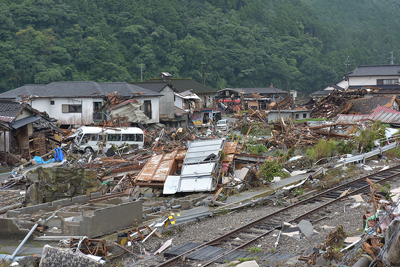
調査速報:令和2年7月豪雨による熊本県人吉市および球磨村渡地区の洪水被害の特徴

 本プロジェクトの内山さんが、令和2年7月豪雨による熊本県人吉市および球磨村渡地区の洪水被害状況について調査を実施し、速報を公開しました。以下のURL(防災科研HP)から本文を閲覧できます。


○要旨
 熊本県人吉市および球磨村は、同県南部を西流する球磨川流域の人吉盆地に位置する。この地域の上流側にある6つのアメダス観測点では、2020年7月3日から4日までの48時間で、418.5mmから497mmの雨量が記録された。これは、人吉市総合防災マップ(2017)の浸水想定における雨量(48時間で440mm)と同規模であった。7月3日明け方から降り始めた雨は、7月4日午前0時ころより急激に降水量が増加し、以降、10分間降水量で10mmを超える豪雨が、三度、断続的に発生した。この結果、24時間雨量では50年確率降水量(気象庁HP)を超過し、かつ、球磨川では、既往最大水位(2015年6月6日、4.16m)を超過した。人吉市では7月4日午前5時15分に避難指示が発令されたものの、球磨川やその支流で氾濫が生じ、氾濫流による建物・橋梁の破壊・流失、および浸水による被害が生じた。また、19名の死亡が確認された(7月11日時点)。

 現地調査は7月9日に実施し、被害の様相および浸水深を写真で記録し(以降、実績浸水深とよぶ)、既存の洪水ハザードマップ(人吉市、2017)で示された想定浸水範囲および想定浸水深との対比を行った。この結果、浸水範囲・浸水ともにハザードマップと調和的であったものの、想定浸水範囲は少し外側に広がり、また、想定浸水深が浅いところで実績浸水深が超過する傾向がみられた。このほか、細い水路の周辺で、局地的に高い浸水被害が生じた。また、人的被害は浸水深の深い地区に偏在している可能性が示唆された。

 これらの結果から、洪水ハザードマップは、実際の浸水被害を比較的正確に予測していると考えられる。このことは、洪水対策、避難計画、災害対応における洪水ハザードマップの有効性を示唆している。一方で、既存のハザードマップから、氾濫流による破壊的な被害が生じうること、およびその発生場所を読み取ることはできなかった。局地的な想定浸水深の大幅超過が生じた原因と合わせて、今後の詳細な検討が求められる。
なお、本報告は速報のため、今後の調査・解析により内容を修正することがある。


2020/07/05

JpGU-AGU Joint Meeting 2020 地形鮮明化プロジェクト 発表リスト

2020年7月12日(日)~16日(木)、JpGU-AGU Joint Meeting 2020がオンラインで開催されます。地形鮮明化プロジェクト関連発表をまとめました。それぞれの発表タイトルから予稿をご覧いただけます。また、地形鮮明化プロジェクトでは、セッションM-TT47"HIGH-DEFINITION TOPOGRAPHY AND GEOPHYSICAL DATA IN THE ANTHROPOCENE"(人新世における高精細地形・地球物理データ解析)を主催しております(EGU, AGUとのJoint Session)。7月12日(日)9:00-9:45にDFS(Discussion Forum Session)が設定されております。


※リスト中の[EE]は英語セッション、[JJ]は日本語セッションです。

[H-TT19] 地理情報システムと地図・空間表現