ラベル 防災 の投稿を表示しています。 すべての投稿を表示

2021/03/29

新着論文:総合的な学習の時間を活用した地理・地形教育の実践 -地域文化資源を用いた小規模公立小学校への地域学習から-

 日本地形学連合の機関紙「地形」に、本プロジェクトの早川と小倉が連名の論文が採択されました。

 田村裕彦・早川裕弌・守田正志・小口千明・緒方啓介・小倉拓郎(2020.12)総合的な学習の時間を活用した地理・地形教育の実践-地域文化資源を用いた小規模公立小学校への地域学習から-.地形, 41-4, 343-361.

 田谷の洞窟保存実行委員会の活動の一環で行われている横浜市立千秀小学校における総合的な学習の時間・特別授業について、授業実践の経緯・内容を記録したものです。
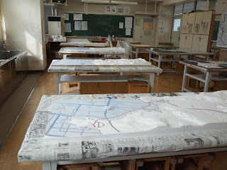
 地形鮮明化プロジェクトでは、2017年度よりこの活動に参画し、田谷の洞窟の地上レーザ測量成果を使った洞窟輪切り断面模型の制作、航空レーザ測量成果を用いた田谷地域の大型地形模型の製作、横浜市栄区洪水ハザードマップを大型地形模型に重ね合わせた災害被害立体模型の製作に関わってきました。


ちなみに、今号の地形の表紙には模型製作実習の様子がうつっています


2021/02/12

受賞:優秀研究動画賞・防災科研令和2年度成果発表会

 本プロジェクトの内山さんが、防災科学技術研究所令和2年度成果発表会にて、ベスト3にあたる優秀研究動画賞を受賞しました。防災科研では、今年度の成果発表会をオンラインで開催し、研究者一人ひとりによる動画での成果研究の発表を行いました。その中で、動画に対する「高評価」を多数いただき、受賞に至りました。


成果発表会動画


研究紹介
内山庄一郎:ドローン災害対応システムGEORIS(ジオリス)の紹介


2020/11/05

EGU 2021 "vEGU21" session "NH6.1 Remotely Piloted Aircrafts Systems (RPAS) for Natural Hazard Characterization and Risk Assessment" / 欧州地球科学連合2021セッション「自然災害評価とリスクアセスメントのための無人航空機の活用」発表募集

例年、ウィーンで開催されるEGU(欧州地球科学連合)は、来年2021年は完全オンラインで行われることとなりました。4月19〜30日の期間です。この"vEGU21"でも、無人航空機と自然災害のセッションを例年通り開催いたします。オンラインのため全世界から参加しやすくなっており、欧州に限らず、日本を含むアジア、オセアニア、またその他の地域にお住まいの皆様からも、多くの発表をお待ちしております。

なお、今年の2020年EGUもすべてオンラインでの開催となりましたが、その際も当セッションは活況で、チャットに加えてリアルタイムビデオミーティングも行い、有益な議論を交わすことができました。


We would like to invite you to contribute to the following 2021 EGU (vEGU21) SESSION:

NH6.1 - Remotely Piloted Aircrafts Systems (RPAS) for Natural Hazard Characterization and Risk Assessment

Convener: Daniele Giordan
Co-Convener: Marc Adams, Yuichi S. Ayakawa, Francesco Nex, Fabio Remondino

SESSION DESCRIPTION
https://meetingorganizer.copernicus.org/EGU21/session/39031

The use of Remotely Piloted Aircraft Systems (also called UAS) for natural hazard characterization and hazard assessment has sharply increased in the last years. Nowadays, the massive diffusion of mini- and micro-RPAS is becoming a valuable alternative to the traditional monitoring and surveying techniques, opening novel and exciting viewpoints. The advantages of the use of RPAS are particularly crucial in areas characterized by hazardous natural processes, where the acquisition of high resolution remotely sensed data could be a powerful instrument to quickly assess the damages and plan effective rescues without any risk for operators.

In general, the primary goal of these systems is the collection of different data (e.g., images, LiDAR point clouds, gas or radioactivity concentrations) and the delivery of various products (e.g., 3D models, hazard maps, high-resolution orthoimages).

The use of RPAS has promising perspectives not only for natural hazards, but also in other fields of geosciences, to support a high-resolution geological or geomorphological mapping, or to study the evolution of active processes. The high repeatability of RPAS flights and their limited costs allows the multi-temporal analysis of a studied area. However, methodologies, best practices, advantages and limitations of this kind of applications are yet unclear and/or poorly shared by the scientific community.

This session aims at exploring the open research issues and possible applications of RPAS in particular for natural hazard but also for geosciences in general, collecting experiences, case studies, and results, as well as defining methodologies and best practices for their practical use. The session will concern the contributions aiming at i) introducing new methods for using RPAS in natural hazard scenarios, including autonomous flights ii) describing the development of new onboard sensors and fusion methodologies for the acquisition data with RPAS, iii) reporting new data processing methods, e.g. based on machine learning, for image or point cloud segmentation and classification, and iv) presenting original case studies that can be considered an excellent example for the scientific community.


Please, pass this information to anyone who might be interested and feel free to contact us if you need any help or support.

Looking forward to meeting you virtually!

Warmest Regards

Daniele Giordan, Marc Adams, Yuichi S. Hayakawa, Francesco Nex, Fabio Remondino


THE DEADLINE FOR ABSTRACT SUBMISSION IS: 
13 JANUARY 2021 at 13:00 CET


INSTRUCTIONS FOR ABSTRACT SUBMISSION
https://www.egu21.eu/abstracts_and_programme/how_to_submit_an_abstract.html

An Abstract processing charge of €40 gross must be paid for each abstract submission. For late abstracts a higher APC of €80 gross will be invoiced.

All first authors of abstracts submitted to the General Assembly 2021 have to be 2021 EGU members. The membership can be acquired upon abstract submission.

Guidelines for abstract submission can be found at:

 
Additional information

Please note that participation to vEGU21 will be allowed after the payment of a registration fee.

The registration fees are waived for (a) scientists receiving an EGU award or medal, (b) scientists with a permanent affiliation in a low- or lower-middle income country according to the World Bank definition, (c) PhD candidates from all middle income countries according to the World Bank definition, (d) 2021 EGU emeritus members, and (e) undergraduate or master students.

Full information about the EGU2021: https://egu21.eu/about/general_information.html


2020/05/19

新着書籍:新版・必携ドローン活用ガイド―災害対応実践編ー

 本プロジェクトの内山庄一郎さんが、新しい書籍「新版・必携ドローン活用ガイド―災害対応実践編ー」を出版されました。「必携ドローンガイド」シリーズは2冊目となります(1冊目はこちら)。
 この本では、「なぜドローンを飛ばすのか?」「それはドローンで見えるのか?」「広域災害にいかに立ち向かっていくか」という3つの問いに答えるとともに、訓練から現場展開までの道筋を解説されています。
 また、巻末には、災害対応の専門的な観点から、オルソ画像作成する仕組みを解説する附録がついております。
 以下のリンクから購入できます。ぜひ1ユーザーに1冊必携!でよろしくお願いいたします。


2020/02/14

開催報告:横浜市立千秀小学校 田谷周辺における被災状況地形模型の制作

2020年2月14日(金)、本プロジェクトの早川と小倉が、横浜市立千秀小学校6年生の総合的な学習の時間にて、地域防災に関する授業に参画しました。
横浜市立千秀小学校・田谷の洞窟保存実行委員会による環境教育の実践は今年度で3年目。今年度は、1年目に制作した田谷地域の大型地形模型に、昨年甚大な被害をもたらした台風15号・台風19号の被災状況をマッピングするという取り組みです。
※今年度のこれまでの取り組みは田谷の洞窟保存実行委員会HPにて詳しくまとめられています。

授業は図工室で実施。クラスを4班に分けて、担当した地域の被災状況を調べました。
この時間以前に、横浜国立大学の守田正志准教授と研究室の院生・学生らが、模型製作にかかわる授業を行っておりました。

児童たちは、まず台風が通り過ぎた後の地域の様子について聞き取りや現地観察を行い、地域で起こった小さな変化についてまとめました。
ex. 植木鉢が倒れた、浸水した、風邪で信号が傾いた など…

その上で、その現象が発生した場所について地図と地形模型を見比べながら、地形模型にマッピングしていきます。

模型の上の道やピクトグラムは児童らが作成し、貼り付けました。
また、低地には横浜市栄区のハザードマップから浸水予想エリアを抽出し、貼り付けました。

できた模型がこちら!!

この模型から、防災・減災について考えていきます。

児童たちは、上から見たり、横から見たり…
ピクトグラムと地形との関係などを考えていきます。

授業では、本プロジェクトの早川・小倉と、守田先生、田谷の洞窟保存実行委員会の田村裕彦さんを交えて、田谷地域で発災した箇所の特徴に関する考察を行いました。

浸水被害が大きい場所は、どんな地形であったのか?
風の被害が大きいのはどのような特徴があるのか?
山のかたちが違うのはなぜなのだろうか?
また、それぞれの土地利用はどのようなものであったのだろうか?

1時間かけてゆっくり議論し、模型製作のまとめとしました。

最後に、教室で給食をいただきました!
児童たちは授業以外では見られなかった先生方の素顔も見られたかも??
大盛況のうちに、ごちそうさまでした!の挨拶を終えて、次の授業の準備です。


参考URL

2017/11/29

national meeting on "BOSAI" – disaster prevention / 「ぼうさいこくたい」

去る2017/11/26-27、仙台国際センターで開催された「防災推進国民大会2017(ぼうさいこくたい)」における防災学術連携体によるイベント「衛星情報・地理情報と防災イノベーション」で、地理学会として下記ポスター展示を行ってきました。

『高精細地形情報を用いた津波痕跡の発見と保存:三陸海岸を例に』
Discovery and preservation of evidence of tsunamis using high-definition topographic data along Sanriku Coast


会場は、ぼうさいこくたい・防災産業展・World BOSAI Forumが同時開催で、たいへん賑やかでした。

受付付近

ポスター展示会場

口頭発表会場